Utah Studies
Google Earth on the Range
Grade Level(s)
6 - 8
Purpose
Students will study Utah geography, history, and economics by examining rangelands using Google Earth and repeat photography.
Estimated Time
1 hour
Materials Needed
Interest Approach
- America's Heartland video Utah Cattle Drive—Ranching Round-Up
Activity 1
- Repeat Photographs of Rangelands, laminated and cut apart
- A Google Earth on the Range Repeat Photographs Kit is available for purchase.
- Google Earth
- Repeat Photographs in Google Earth file
Concept Elaboration and Evaluation
Option 1
- Utah Rangelands Discussion activity sheet
- The Utah Journey textbook
Option 2
- Computer with internet access for each student
- Ridin' the Range Webquest
- Ridin' the Range Webquest Answer Key
Essential Files (maps, charts, pictures, or documents)
- Repeat Photographs in Google Earth File
- Repeat Photographs of Rangelands
- Ridin' the Range Webquest Answer Key
- Utah Rangelands Discussion Activity Sheet
Vocabulary Words
- biodiversity: biological diversity in an environment as indicated by numbers of different species of plants and animals
- carrying capacity: the maximum number of animals a piece of land can support without degradation
- forage: food for animals especially when taken by browsing or grazing
- rangeland: open land vegetated mainly by native grasses, forbs, and shrubs used by grazing wildlife and livestock
Did You Know? (Ag Facts)
- Rangelands cover about 45 percent of the earth's land surface.1
- About 36 percent of the land in the United States is rangeland.1
- Over 80 percent of Utah's land is rangeland.1
Background Agricultural Connections
Utah's natural resources define it as a state. No study of Utah would be complete without an examination of its public lands and the multiple uses they offer, including livestock grazing, wildlife habitat, watershed preservation, recreation, and more. For a state that depends on livestock as a major source of agricultural income, rangeland sciences and management are very important.
When the term rangeland first came into use in the 1800s, it was used to describe the extensive, unforested lands dominating the western half of North America. Today, rangeland refers to a large, mostly unimproved section of land that is used for livestock grazing. Rangelands can be found in a wide variety of ecosystems, including natural grasslands, savannas, shrublands, deserts, tundras, alpine communities, coastal marshes, and wet meadows. Rangelands are usually mountainous, rocky, or dry areas that aren't suitable for growing the usual farm crops. However, grass and other plants on this rangeland can be used for grazing livestock. People can't eat grass, but cattle and sheep can turn grass into beef and lamb.
Rangeland is a precious natural resource that can be damaged by overgrazing, which can lead to erosion, flooding, and decreased biodiversity. To prevent these problems, ranchers in Utah have worked with the Forest Service since the early 1900s to monitor and manage the state's public rangelands, using scientific techniques to measure the impact that domesticated animals have on the landscape. Careful management of grazing has reduced soil erosion problems and improved the health of many of Utah's rangelands, but some areas face different challenges.
Over the last century, pinyon, juniper, sagebrush, and other woody plants have increased significantly on Utah's rangelands. This is important because as populations of woody plants increase, grasses and forbs decline. More wildlife and livestock can graze on grasses and forbs than on woody plants, so this change means a reduction in the carrying capacity of the land. Historically, frequent, low-intensity fires limited the spread of woody species like pinyon, juniper, and sagebrush into Utah's grasslands. Fire suppression has played a role in allowing populations of woody species to increase.
Fire suppression and grazing management also impact Utah's aspen communities, which are being replaced by coniferous forests in many locations. Aspen communities are important for many reasons. They support high biodiversity; as Utah's aspen populations decline, so does the state's biodiversity. There is also evidence that aspen communities facilitate water conservation, meaning stream flows may decline as they are replaced by conifers. Additionally, coniferous forests allow very little understory vegetation, shading out competition and acidifying the soil pH as their needles accumulate on the forest floor. In contrast, aspen stands are more open and do not change the soil pH, allowing more forage plants to grow in the understory. One photographic example of this can be seen in the first photograph of Bee Lake on Boulder Mountain taken in 1872 (see the Repeat Photographs of Rangelands), which shows the original density of the aspen forest. At the time of the second picture in 1996, the lake was unnamed, the aspens had declined, and the water level had dropped.
Other examples can be observed throughout the Fishlake National Forest, where aspen acreage has declined by about half in the last 100 years. As aspen communities have been converted to conifers, AUMs (animal unit months)—the standard measure used to calculate how many animals an acre of land can support—have been lost. This is a major concern for range scientists. Not only is there less forage to support the livestock industry, but there is also less habitat for wildlife. The forage plants that elk and mule deer prefer have also declined as conifers have increased.
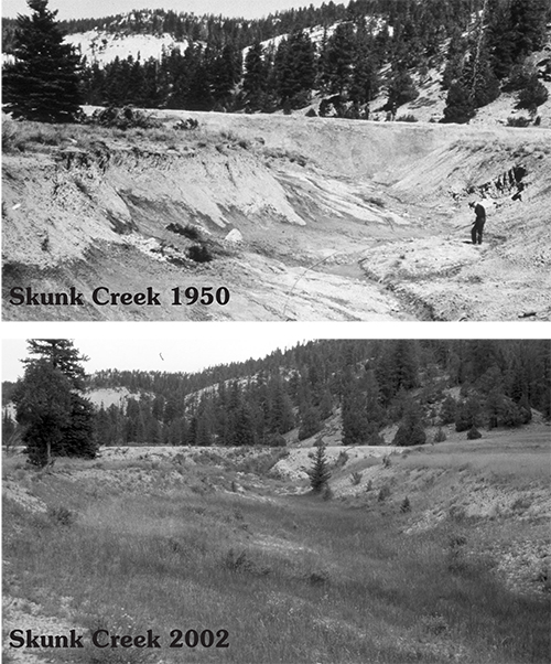
Repeat photography has documented many of the changes that occur on Utah's rangelands over time. Visual documentation of the state's rangeland began with early pictures taken by the Forest Service. Utah State University Extension has worked to track down the original locations of these photos and arrange the follow-up photography to be as similar in the frame as possible. They maintain a database to show how the landscape is changing, for better or worse. The database can be viewed from the Utah's Rangeland website; but many of the highlights have been included as part of this lesson plan.
Interest Approach – Engagement
- Ask the students to help you make a list on the board of all the types of farms they have seen in Utah. This list can include farms that are nearby as well as those they may have seen on a road trip in other areas of the state. As you list each type of farm, list the food they produce as well. For example if a student lists a dairy farm, specify that it produces milk.
- When your brainstorm is complete, explain to the students that they will be learning about different factors that determine where food is grown. Some of their food is grown close by, and other food is not.
Procedures
Activity 1: Where does my food come from?
- Show students the first four minutes of the America’s Heartland video Utah Cattle Drive—Ranching Round-Up.
- Use the following questions as a guideline to discuss the video:
- What was the purpose of the cattle drive? (To move the cows to summer pasture.)
- Why might cows be kept in different places in the summer and winter? (In the heat of summer, pastures at higher elevations often have more green grass for longer than lower elevations. In the winter, high elevation pastures have inhospitable weather. Additionally, many ranchers have permits to graze on public lands for a specified period of use each year, meaning the animals must be moved in when the period begins and out when the period ends.)
- Who participated in the cattle drive? (Ranch family members and paying customers who wanted the experience.)
- Why do ranchers raise cattle? (Cattle are sold for beef; many by-products, such as leather, also come from beef cattle. Ranching and raising cattle is also a lifestyle and tradition.)
- Explain to students that grazing is one way to make use of rugged landscapes that are otherwise unsuitable for agriculture. These same landscapes are also valued for recreation, wildlife habitat, and other uses. In the following activity, students will explore how landscapes change over time and how different land uses affect people and the environment.
Procedures
Activity 1: Change on the Range
- Provide each student with a landscape photo. Inform them that they have either a "before" or "after" picture, and that they need to find their partner who has the matching landscape. Students may find the following suggestions useful when looking for their matching landscape:
- Human-made structures, trees, and other plants come and go over time, so they are not always a reliable method of identifying a landscape.
- Erosion may increase or decrease in an area, but that usually does not significantly change the topography (the lay of the land—slopes, boulders, curvatures, etc.), so looking for these features first is a good starting point.
- Once students have located their partners, have students guess which picture is the "before" and which is the "after."
- Share the background information with students and introduce the vocabulary. Have them discuss and then write a paragraph that describes their landscape based on what they learned from the background information.
- At this point, students are ready to explore Google Earth to find the location of their pictures, read the official description of their landscape, and compare that description to their own paragraph. There are two options for this step, depending on what kind of technology is available:
- Option 1—If a computer lab is available, download the zipped file Repeat Photographs in Google Earth onto each computer, extract it, and open it in Google Earth. Explain the mechanics of Google Earth, and allow students to explore on the map on their own or through a teacher-led discussion.
- Option 2—If a computer with projection is available, conduct a teacher-led discussion of the material, while each group has the chance to maneuver through the Google Earth area around their picture location. Information in the Repeat Photographs in Google Earth file will show students the exact latitude and longitude where the camera was placed for each picture, the year each picture was taken, and what the pictures mean in context of erosion and rangeland management.
Concept Elaboration and Evaluation
Both of the following activities will help students more deeply understand the concepts discussed in the Change on the Range landscape photo activity:
- Option 1—Use the attached Utah Rangelands Discussion activity sheet and the seventh grade textbook The Utah Journey to further explore Utah’s land resources and assess student understanding.
- Option 2—Have students complete the Ridin' the Range Webquest. In order to complete this activity, students will need a computer with internet access, the link to the webquest, and an email to send the finished webquest to (provide them your email if you would like to receive their finished work). Within the webquest, students will be directed to the following websites to find answers to the questions:
After conducting these activities, review and summarize the following key concepts:
- Public lands have multiple uses that are important to many different groups of people.
- Each land use carries a specific set of benefits and consequences that affect people and the environment.
- Grazing cattle for beef production is one use of public lands. Grazing can be beneficial to the environment if it is managed properly or harmful to the environment if poorly managed.
- Rangelands can be public or private land. They are located in open spaces where there is forage beneficial to grazing livestock, and they are generally not ideal for crop farming due to a variety of factors which can include rugged topography, limited water resources, etc.
- Rangelands are defined in part by their physical geography. Physical geography affects what plants and animals live in an area as well as what kinds of activities humans undertake in an area.

Enriching Activities
- Have students do a close reading of the Utah State University Extension article Federal Lands Grazing Permits: Managing Rangeland Resourcesto further explore the modern and historical challenges of ranching and rangeland management.
- Use the Ranch Starter Kit to have students start their own "ranch" and learn how grazing can help or hurt rangelands.
- Use the video Time-Controlled Grazing to show students how close management of grazing can benefit both livestock and the environment.
Sources
Suggested Companion Resources
- Google Earth on the Range Repeat Photographs
- Ranch Starter Kit
- Changes & Challenges: Utah Agriculture
- Illustrated Accounts of Moments in Agricultural History
- NMSU Field Trip: Beef
- Riding the Range on a Utah Cattle Drive
- TedTalk- How to Fight Desertification and Reverse Climate Change
- Esri GIS for Agriculture
Author(s)
Lyndi Perry and Debra Spielmaker
Organization Affiliation
Utah Agriculture in the Classroom
- Investigate the relationship between physical geography and Utah’s settlement, land use, and economy. Meeting one or more of the following indicators: a) Read and interpret a variety of maps. b) Identify the physical features and regions of Utah. c) Compare and contrast the relationship between physical features and regions to settlement, land use, and the economy.
- Examine the interrelationship between Utah’s climate, location, landforms, and life. Meeting one or more of the following indicators: a) Describe how latitude, elevation, and distance from the ocean influence Utah’s climate. b) Explain how mountains, valleys, and bodies of water affect climate. c) Assess how climate influences life in Utah. d) Explain how natural forces shape the living environment and landscape. e) Investigate how natural forces shape the local environments. f) Predict how natural forces affect environments; e.g., earthquakes, volcanic action, mudslides, flooding, erosion.
- Assess how natural resources sustain and enhance people’s lives. Meeting one or more of the following indicators: a) Recognize the impact of water, minerals, wildlife, and forests on people. b) Distinguish between renewable and non-renewable resources. c) Analyze how natural resources improve the quality of life. d) Assess the importance of protecting and preserving natural resources.
- Examine how people affect the geography of Utah. Meeting one or more of the following indicators: a) Identify Utah’s counties and cities. b) Assess how people change the landscape. c) Examine how altered landscapes affect people.
- Investigate the past and present role of agriculture in Utah. Meeting one or more of the following indicators: a) Identify the importance of farming and ranching to Utah’s economy. b) Explain the impact of the Great Depression on farmers and agriculture. c) Investigate how agriculture has diversified and improved over time. d) Examine the cultural legacy of agriculture in Utah.
- Investigate the current status of Utah’s economy. Meeting the following indicator: c) Explain the effects of private, state, and federal land ownership on land use; i.e., parks, forests, trust lands, etc.
- Discuss (from multiple perspectives) land and water use by various groups (i.e., ranchers, farmers, hunters, miners, recreational users, government, etc.), and how each use carries a specific set of benefits and consequences that affect people and the environment (T1.6-8.d)
- Recognize how climate and natural resources determine the types of crops and livestock that can be grown and raised for consumption (T1.6-8.g)
- Geospatial technologies--Internet-based mapping applications, GIS, GPS, geovisualization, and remote sensing-- can be used to construct geographic representations using geospatial data.
- Concepts such as: chronology, causality, change, conflict, complexity, multiple perspectives, primary and secondary sources, and cause and effect.
- Past and present changes in physical systems, such as seasons, climate, and weather, and the water cycle, in both national global contexts.
- Acquire and use accurately a range of general academic and domain-specific words and phrases sufficient for reading, writing, speaking, and listening at the college and career readiness level; demonstrate independence in gathering vocabulary knowledge when encountering an unknown term important to comprehension or expression.
